Druridge Bay North

Status: No water quality alerts in place


Sitting at the northern end of a long sandy bay, Druridge Bay North is a gently sloping, remote beach backed by sand dunes with large areas of sand exposed as the tide ebbs. A number of sewer overflows are located in the surrounding area that may affect bathing water quality here although none discharge directly onto the beach.


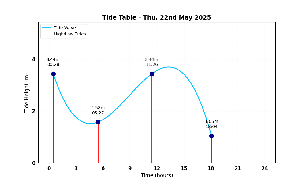
Tide Table for Druridge Bay North Tide Table

Map

Tide Times

Based on the tide information at Amble 2.9 miles away

Thu, 22nd May 2025

  • Low Tide: at 05:27 (1.97m)
  • High Tide: at 11:27 (4.30m)
  • Low Tide: at 18:05 (1.31m)
  • High Tide: at 00:28 (4.30m)

Fri, 23rd May 2025

  • Low Tide: at 06:31 (1.75m)
  • High Tide: at 12:30 (4.51m)
  • Low Tide: at 19:03 (1.08m)

Sat, 24th May 2025

  • High Tide: at 01:23 (4.53m)
  • Low Tide: at 07:27 (1.47m)
  • High Tide: at 13:27 (4.76m)
  • Low Tide: at 19:58 (0.87m)

Weather Overview


Current Weather

Temperature: ❄️ 8.8°C

Wind Speed: 16.2 km/h - 🌿 (Gentle Breeze)

Forecast for 22 May 2025

Max Temp: 🌤 10.9°C

Min Temp: ❄️ 7.3°C

🌅 Sunrise: 04:44

🌇 Sunset: 21:21

Precipitation: 🌦️ Light Rain 0.3 mm

Wind: 💨 Strong Breeze 29.5 km/h

Forecast for 23 May 2025

Max Temp: 🌤 11.0°C

Min Temp: ❄️ 5.2°C

🌅 Sunrise: 04:43

🌇 Sunset: 21:22

Precipitation: ☀️ No Rain 0.0 mm

Wind: 🌿 Gentle Breeze 16.9 km/h


Data Sources and Organisations

Our project utilises data from the following organisations:

We extend our gratitude to these organisations for their valuable data to help ensuring safe swimming conditions.