Llangrannog

Status: No water quality alerts in place


Measuring just over 100 metres in width, with interbedded mudstone and sandstone cliffs on either side, the sandy, sheltered beach has a distinctive large rock on the shore?s edge. This location is covered by Pollution Risk Forecasting.


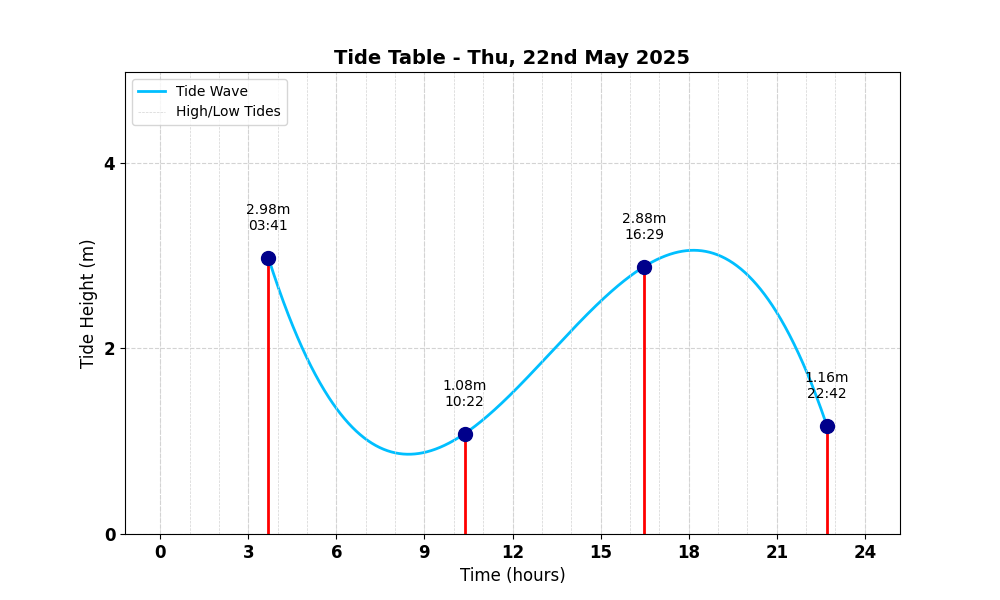
Tide Table for Llangrannog Tide Table

Map

Tide Times

Based on the tide information at Aberporth 3.8 miles away

Thu, 22nd May 2025

  • High Tide: at 03:41 (3.72m)
  • Low Tide: at 10:22 (1.35m)
  • High Tide: at 16:29 (3.60m)
  • Low Tide: at 22:43 (1.45m)

Fri, 23rd May 2025

  • High Tide: at 04:50 (3.96m)
  • Low Tide: at 11:24 (1.19m)
  • High Tide: at 17:28 (3.93m)
  • Low Tide: at 23:49 (1.23m)

Sat, 24th May 2025

  • High Tide: at 05:48 (4.25m)
  • Low Tide: at 12:25 (1.01m)
  • High Tide: at 18:20 (4.28m)
  • Low Tide: at 00:52 (0.99m)

Weather Overview


Current Weather

Temperature: 🌤 12.8°C

Wind Speed: 8.3 km/h - 🌾 (Light Breeze)

Forecast for 22 May 2025

Max Temp: 🌤 14.0°C

Min Temp: ❄️ 10.0°C

🌅 Sunrise: 05:12

🌇 Sunset: 21:16

Precipitation: ☀️ No Rain 0.0 mm

Wind: 💨 Strong Breeze 23.0 km/h

Forecast for 23 May 2025

Max Temp: 🌤 14.8°C

Min Temp: ❄️ 9.3°C

🌅 Sunrise: 05:11

🌇 Sunset: 21:17

Precipitation: 🌦️ Light Rain 0.1 mm

Wind: 💨 Strong Breeze 20.5 km/h


Data Sources and Organisations

Our project utilises data from the following organisations:

We extend our gratitude to these organisations for their valuable data to help ensuring safe swimming conditions.