Penmaenmawr

Status: No water quality alerts in place


Situated on the north Wales coastline, 11 kilometres east of Bangor, the beach is sandy at low tide, with stones and pebbles forming the upper bay area. The beach area extends approximately 1 kilometre, with rocks and coastal defences fringing the outer reaches. The coastal water and coastal belt form the Menai Strait and Conwy Bay Special Area of Conservation, confirming the high conservation status of the area.


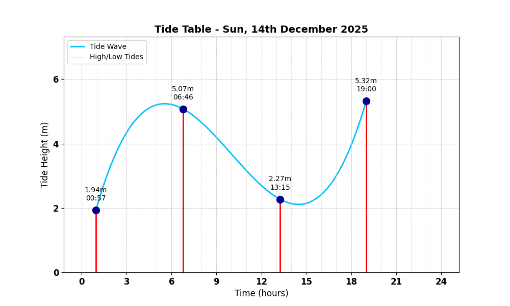
Tide Table for Penmaenmawr Tide Table

Map

Tide Times

Based on the tide information at Conwy 3.9 miles away

Sun, 14th December 2025

  • Low Tide: at 00:57 (2.42m)
  • High Tide: at 06:47 (6.34m)
  • Low Tide: at 13:15 (2.84m)
  • High Tide: at 19:00 (6.65m)

Mon, 15th December 2025

  • Low Tide: at 01:56 (2.42m)
  • High Tide: at 07:43 (6.50m)
  • Low Tide: at 14:17 (2.73m)
  • High Tide: at 19:56 (6.71m)

Tue, 16th December 2025

  • Low Tide: at 02:49 (2.36m)
  • High Tide: at 08:28 (6.74m)
  • Low Tide: at 15:10 (2.56m)
  • High Tide: at 20:43 (6.83m)

Weather Overview


Current Weather

Temperature: 🌤 12.4°C

Wind Speed: 47.2 km/h - 🌪️ (Strong Breeze)

Forecast for 14 December 2025

Max Temp: 🌤 12.5°C

Min Temp: 🌤 10.9°C

🌅 Sunrise: 08:23

🌇 Sunset: 15:57

Precipitation: 🌦️ Light Rain 3.7 mm

Wind: 🌀 Hurricane 57.6 km/h

Forecast for 15 December 2025

Max Temp: 🌤 12.6°C

Min Temp: ❄️ 7.7°C

🌅 Sunrise: 08:24

🌇 Sunset: 15:57

Precipitation: 🌧️ Heavy Rainfall 16.0 mm

Wind: 💨 Strong Breeze 43.9 km/h


Data Sources and Organisations

Our project utilises data from the following organisations:

We extend our gratitude to these organisations for their valuable data to help ensuring safe swimming conditions.