Seatown

Status: No water quality alerts in place


Seatown is a steeply sloping shingle beach backed by crumbly, fossil-rich cliffs. The river Winniford flows across the middle of the beach. A sewer overflow discharges 220m upstream of the beach in the River Winniford.


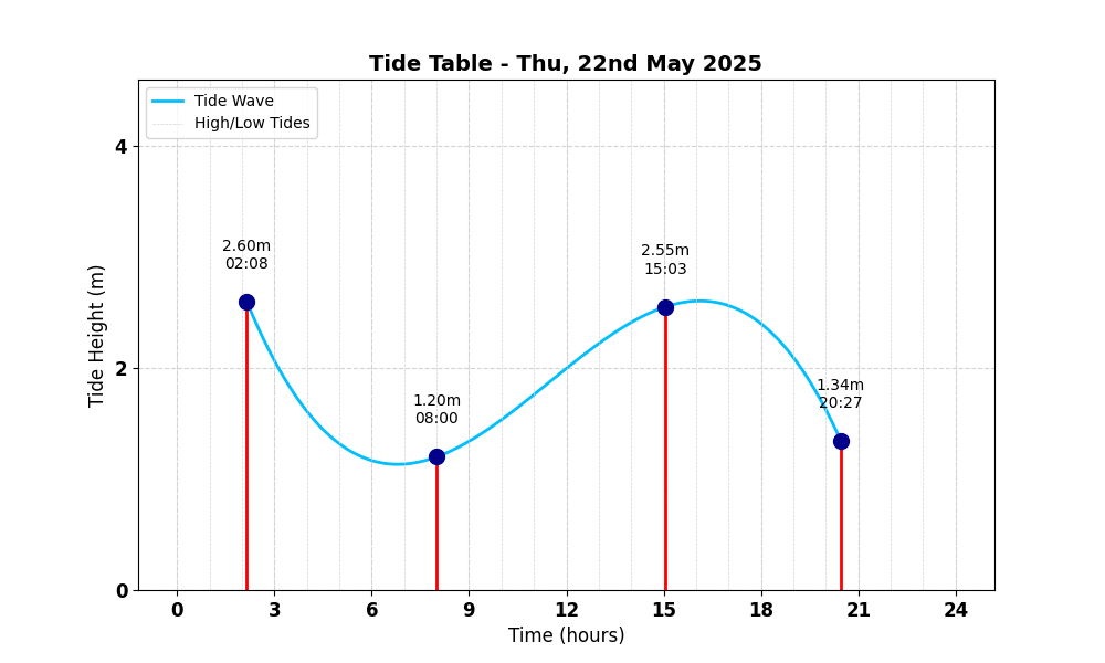
Tide Table for Seatown Tide Table

Map

Tide Times

Based on the tide information at Bridport (West Bay) 2.5 miles away

Thu, 22nd May 2025

  • High Tide: at 02:09 (3.25m)
  • Low Tide: at 08:00 (1.50m)
  • High Tide: at 15:03 (3.19m)
  • Low Tide: at 20:28 (1.68m)

Fri, 23rd May 2025

  • High Tide: at 03:26 (3.41m)
  • Low Tide: at 09:11 (1.31m)
  • High Tide: at 16:11 (3.43m)
  • Low Tide: at 21:37 (1.43m)

Sat, 24th May 2025

  • High Tide: at 04:32 (3.63m)
  • Low Tide: at 10:09 (1.09m)
  • High Tide: at 17:10 (3.71m)
  • Low Tide: at 22:34 (1.16m)

Weather Overview


Current Weather

Temperature: ❄️ 10.0°C

Wind Speed: 10.4 km/h - 🌾 (Light Breeze)

Forecast for 22 May 2025

Max Temp: ☀️ 20.7°C

Min Temp: ❄️ 9.9°C

🌅 Sunrise: 05:12

🌇 Sunset: 21:03

Precipitation: ☀️ No Rain 0.0 mm

Wind: 🌿 Gentle Breeze 15.9 km/h

Forecast for 23 May 2025

Max Temp: 🌤 16.6°C

Min Temp: ❄️ 8.3°C

🌅 Sunrise: 05:11

🌇 Sunset: 21:04

Precipitation: 🌦️ Light Rain 0.1 mm

Wind: 💨 Strong Breeze 29.5 km/h


Data Sources and Organisations

Our project utilises data from the following organisations:

We extend our gratitude to these organisations for their valuable data to help ensuring safe swimming conditions.