Tresaith

Status: No water quality alerts in place


This is a small, sheltered, sandy bay, named after the River Saith, which cascades as a waterfall over the limestone cliffs onto the north of the beach. Facing north west, the bay is relatively small, at approximately 250 metres wide. The coastal waters and coastal belt is designated as Cardigan Bay Special Area of Conservation, confirming the high conservation status of the area.


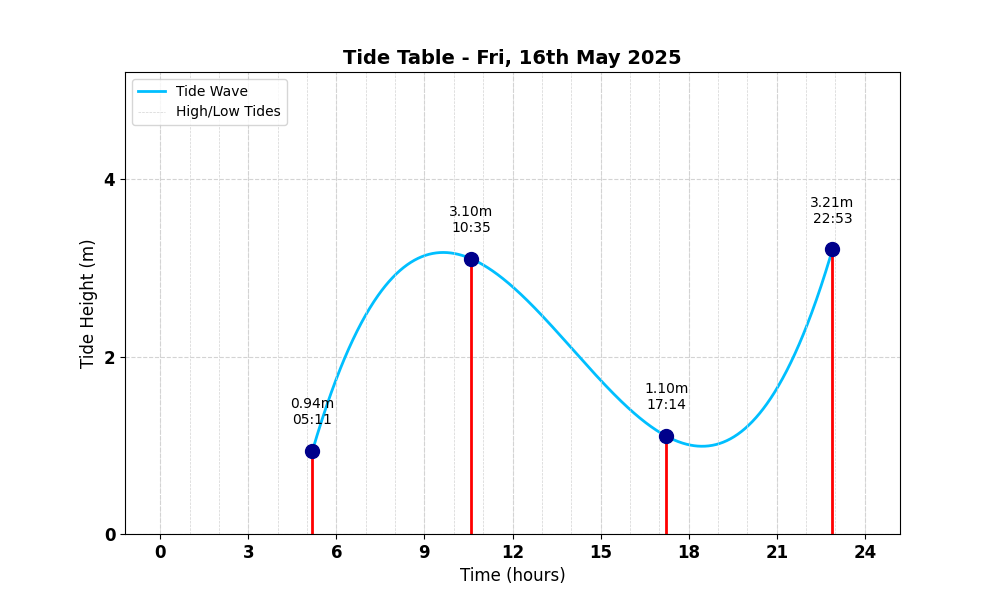
Tide Table for Tresaith Tide Table

Map

Tide Times

Based on the tide information at Aberporth 1.4 miles away

Fri, 16th May 2025

  • Low Tide: at 05:11 (1.17m)
  • High Tide: at 10:35 (3.88m)
  • Low Tide: at 17:14 (1.38m)
  • High Tide: at 22:54 (4.01m)

Sat, 17th May 2025

  • Low Tide: at 05:53 (1.30m)
  • High Tide: at 11:11 (3.69m)
  • Low Tide: at 17:51 (1.53m)
  • High Tide: at 23:30 (3.88m)

Sun, 18th May 2025

  • Low Tide: at 06:39 (1.42m)
  • High Tide: at 11:53 (3.51m)
  • Low Tide: at 18:37 (1.66m)
  • High Tide: at 00:15 (3.74m)

Weather Overview


Current Weather

Temperature: ❄️ 9.1°C

Wind Speed: 15.8 km/h - 🌿 (Gentle Breeze)

Forecast for 16 May 2025

Max Temp: 🌤 14.5°C

Min Temp: ❄️ 8.9°C

🌅 Sunrise: 05:21

🌇 Sunset: 21:07

Precipitation: ☀️ No Rain 0.0 mm

Wind: 🌿 Gentle Breeze 18.0 km/h

Forecast for 17 May 2025

Max Temp: 🌤 15.9°C

Min Temp: ❄️ 7.3°C

🌅 Sunrise: 05:19

🌇 Sunset: 21:09

Precipitation: ☀️ No Rain 0.0 mm

Wind: 🌿 Gentle Breeze 16.2 km/h


Data Sources and Organisations

Our project utilises data from the following organisations:

We extend our gratitude to these organisations for their valuable data to help ensuring safe swimming conditions.