Tynemouth King Edwards Bay

Status: No water quality alerts in place


A gently sloping, sheltered sandy bay located just to the north of the mouth of the River Tyne with Tynemouth Castle towering over it. Enclosed by high cliffs, the rural quality of the beach is juxtaposed by the urban area surrounding it. There are no sewer overflows discharging directly onto King Edwards Bay, however a large number of overflows discharge into the River Tyne just south of the beach.


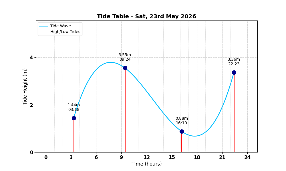
Tide Table for Tynemouth King Edwards Bay Tide Table

Map

Tide Times

Based on the tide information at River Tyne (North Shields) 1.4 miles away

Sat, 23rd May 2026

  • Low Tide: at 03:19 (1.80m)
  • High Tide: at 09:25 (4.44m)
  • Low Tide: at 16:10 (1.10m)
  • High Tide: at 22:24 (4.20m)

Sun, 24th May 2026

  • Low Tide: at 04:32 (1.93m)
  • High Tide: at 10:35 (4.34m)
  • Low Tide: at 17:20 (1.20m)
  • High Tide: at 23:33 (4.13m)

Mon, 25th May 2026

  • Low Tide: at 05:45 (1.93m)
  • High Tide: at 11:45 (4.31m)
  • Low Tide: at 18:27 (1.23m)
  • High Tide: at 00:38 (4.15m)

Weather Overview


Current Weather

Temperature: ☀️ 20.2°C

Wind Speed: 16.2 km/h - 🌿 (Gentle Breeze)

Forecast for 23 May 2026

Max Temp: ☀️ 21.2°C

Min Temp: 🌤 14.8°C

🌅 Sunrise: 04:44

🌇 Sunset: 21:20

Precipitation: 🌦️ Light Rain 0.2 mm

Wind: 🌿 Gentle Breeze 17.3 km/h

Forecast for 24 May 2026

Max Temp: ☀️ 23.3°C

Min Temp: 🌤 13.6°C

🌅 Sunrise: 04:43

🌇 Sunset: 21:21

Precipitation: 🌦️ Light Rain 0.1 mm

Wind: 🌿 Gentle Breeze 18.7 km/h


Data Sources and Organisations

Our project utilises data from the following organisations:

We extend our gratitude to these organisations for their valuable data to help ensuring safe swimming conditions.