Yaverland

Status: No water quality alerts in place


Yaverland is located at the northern end of Sandown Bay on the south east coast of the Isle of Wight. It is a gently sloping, sandy beach backed by a high sea wall. The beach is popular with recreational water users such as kite surfing, windsurfing and surfing but the sea is sectioned so that there are safe bathing areas for swimmers. A sewer overflow discharges some 200m offshore of the beach here.


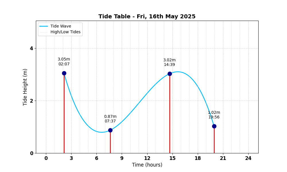
Tide Table for Yaverland Tide Table

Map

Tide Times

Based on the tide information at Sandown 1.0 miles away

Fri, 16th May 2025

  • High Tide: at 02:08 (3.81m)
  • Low Tide: at 07:37 (1.09m)
  • High Tide: at 14:40 (3.78m)
  • Low Tide: at 19:57 (1.28m)

Sat, 17th May 2025

  • High Tide: at 02:43 (3.73m)
  • Low Tide: at 08:15 (1.15m)
  • High Tide: at 15:20 (3.72m)
  • Low Tide: at 20:36 (1.38m)

Sun, 18th May 2025

  • High Tide: at 03:23 (3.62m)
  • Low Tide: at 08:57 (1.25m)
  • High Tide: at 16:10 (3.62m)
  • Low Tide: at 21:25 (1.50m)

Weather Overview


Current Weather

Temperature: 🌤 10.4°C

Wind Speed: 14.5 km/h - 🌿 (Gentle Breeze)

Forecast for 17 May 2025

Max Temp: 🌤 15.7°C

Min Temp: 🌤 10.1°C

🌅 Sunrise: 05:12

🌇 Sunset: 20:49

Precipitation: ☀️ No Rain 0.0 mm

Wind: 🌿 Gentle Breeze 14.5 km/h

Forecast for 18 May 2025

Max Temp: 🌤 16.2°C

Min Temp: ❄️ 9.2°C

🌅 Sunrise: 05:11

🌇 Sunset: 20:50

Precipitation: ☀️ No Rain 0.0 mm

Wind: 🌿 Gentle Breeze 13.2 km/h


Data Sources and Organisations

Our project utilises data from the following organisations:

We extend our gratitude to these organisations for their valuable data to help ensuring safe swimming conditions.